
The vineyard walks I'd happily build a weekend around
Walking through vineyard regions works best when you’re in places where the roads are quiet, the villages sit close together, and you don’t need a car to move between them. That’s the case in parts of Tuscany, rural France, northern Portugal, and several wine areas in Germany. These aren’t long-distance hiking trails built for tourism. They’re local roads, farm tracks, and vineyard paths that connect small villages, wineries, and viewpoints.
A typical day might start in a small town like Montepulciano in Tuscany, where you can walk out of the historic centre and onto the gravel roads that wind between vineyards and olive groves within minutes. In France, places like Eguisheim in Alsace let you leave the village on foot and follow marked vineyard paths straight into the surrounding hills. In Portugal’s Douro Valley, short walks connect small villages and viewpoints above the river, often using the same narrow roads local growers use to reach their terraces. In Germany, routes around Bernkastel-Kues in the Mosel Valley follow the slopes above the river, passing directly through working vineyards.
What makes these walks practical is that you don’t need specialised gear or transport to start them. In most cases, you can leave your accommodation, follow a road out of town, and be among the vines within ten or fifteen minutes. Distances are manageable, routes are flexible, and you can stop in the next village for coffee or a glass of local wine before looping back. This guide focuses on where that’s possible, how the routes work on the ground, and how to build a day around them without needing a car or a fixed plan.
How to plan a vineyard walking day
The easiest way to make vineyard walks work in practice is to anchor your day around one place rather than trying to connect too many. These regions are hilly, roads curve, and distances often feel longer than they look on a map.
Start early from the village you’re staying in. In Gaiole in Chianti, that usually means heading out from Via Ricasoli or Via Spaltenna and following the small road towards Castello di Brolio. Within ten minutes, you’re already walking past vineyards and stone farmhouses. In Pessac, you can begin around Avenue Jean Jaurès or Avenue du Docteur Nancel Pénard, where the houses thin out and the vines begin. In Sabrosa, most people head south towards São Cristóvão do Douro to pick up the start of the PR3 route. In Bernkastel-Kues, the walk begins as soon as you cross the bridge and reach Uferallee, where signs for the Moselsteig appear.
A useful rhythm is to walk one to two hours in the morning, before it gets too warm (especially important in the Douro and parts of Tuscany). This usually covers enough ground to reach a viewpoint or move between villages without rushing. Trying to walk much longer tends to be less enjoyable, especially on exposed vineyard slopes where there’s little shade.
If you want to include a winery visit, book it ahead and treat it as the anchor point of the day. For example, you might walk out in the morning and plan a tasting later at Quinta do Crasto or Weingut Dr. Loosen. Most estates don’t take walk-ins, and walking routes don’t always pass directly by cellar doors, so it’s easier to plan one stop rather than expecting to visit several.
It also helps to keep your route simple. In these regions, out-and-back walks usually work better than trying to create a full loop. Vineyard tracks can look connected on a map but often end at private property or narrow farm access points. Turning back the way you came is usually quicker and avoids dead ends.
Finish the walk back in the same village where you started. In Gaiole, that means returning to the cafés around Piazza Ricasoli. In Pessac, the area around Place de la Ve République has cafés and bakeries where you can sit down after walking. In Bernkastel-Kues, heading back towards Marktplatz puts you close to bakeries and small restaurants near the river. Ending the walk this way means you don’t need extra transport or complicated planning - you basically walk, eat, and reset in the same place.
That’s usually the easiest way to enjoy vineyard walking here: start early, walk a manageable distance, plan one proper stop, and keep the rest flexible.
Getting around matters more than people expect in wine regions, and this guide to Tuscany without a car makes it much easier to see what’s actually realistic day to day.
Tuscany, Italy: vineyard walks around Gaiole and the Via Francigena
Vineyard: Castello di Brolio
Hiking Path: Via Francigena

Castello di Brolio
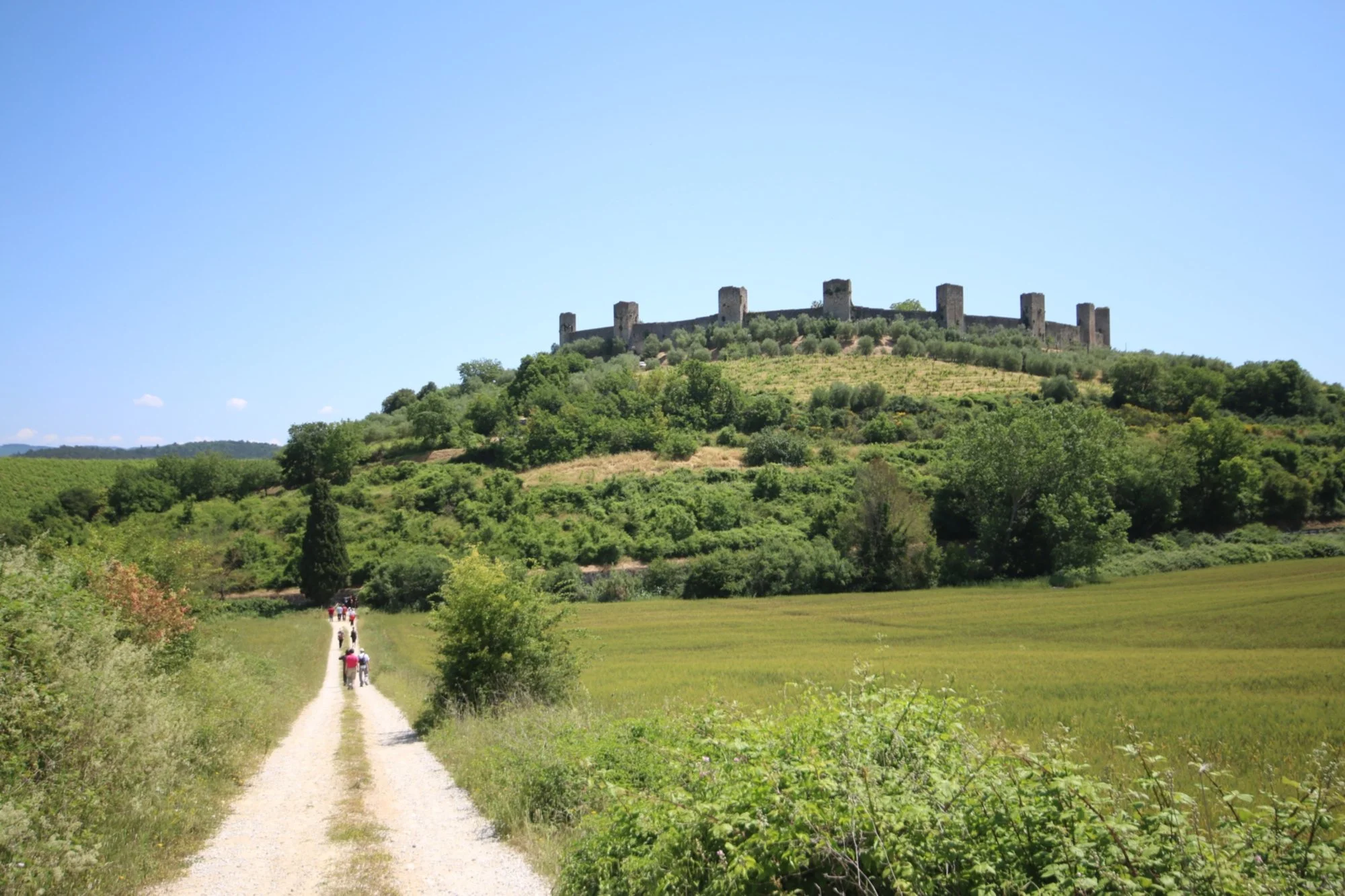
If you want a part of Tuscany where you can actually walk between vineyards instead of driving between them, the countryside around Gaiole in Chianti is a good place to start. The roads here were built long before wine tourism, and they still function as local connectors between farms, small villages, and estates. That makes walking between them feel practical rather than forced.
A good starting point is the centre of Gaiole itself. From Via Ricasoli, you can head out of town on the narrow road that leads towards Castello di Brolio. The road begins to climb almost immediately, and within minutes you’re already passing vineyard plots, olive trees, and the occasional stone farmhouse. It’s a proper road, not a dedicated hiking trail, but traffic is light and the landscape opens quickly once you leave the centre.
The walk up to Castello di Brolio is steady rather than steep, and it’s long enough to feel like a proper outing without being overwhelming. As you gain height, you’ll see the castle rising above the treeline, and the vineyards spread out across the slopes below. You don’t need to enter the castle grounds to enjoy the walk. The approach itself gives you views across the Chianti hills, and there are several spots along the road where you can stop without needing a marked viewpoint.
If you want a longer route, parts of the Via Francigena run through this region. Around the Chianti area, the route follows a mix of gravel tracks, vineyard roads, and short forest sections rather than major roads. You don’t need to walk a full stage of the Via Francigena to make it worthwhile. Many people choose a short section near Gaiole or nearby villages, walking for an hour or two before looping back.
One thing to keep in mind is that distances in this part of Tuscany can feel longer than they look on a map. The roads curve constantly, and even a short walk can include a steady climb. There aren’t many cafés or services once you’re out of town, so it’s worth bringing water and planning a stop back in Gaiole rather than relying on finding something along the way. If you want to combine the walk with a tasting, it’s better to book ahead at one of the wineries near Brolio rather than expecting to drop in.
This area works well if you’re after a day that combines a real walk with a bit of wine culture, without needing a car or a tightly planned route.
If you’re building a slower route through Italy rather than staying in one place, these countryside stays help you figure out where it makes sense to base yourself along the way.
Via Francigena

Via Francigena
Bordeaux, France: vineyard walks around Pessac and Graves
Vineyard: Château Pape Clément
Hiking Path: Les Chemins de la Vigne et du Vin
If you’re staying in Bordeaux, one of the easiest ways to walk among the vines without renting a car is to head out to Pessac, just south of the city. This area sits inside the Graves wine region, and what makes it work is that the vineyards begin right on the edge of town rather than far out in the countryside.
A good place to start is around Château Pape Clément. You can reach it easily on the tram from central Bordeaux (Line B to Pessac Centre), and from there it’s about a 15-minute walk through residential streets to the château. Once you reach the area around Avenue du Docteur Nancel Pénard and Avenue Jean Jaurès, the houses begin to thin out and you start seeing vines almost immediately. The transition from suburb to vineyard is quick, and you don’t need to go far to feel like you’ve left the city behind.
The walking here follows a mix of small paved roads, gravel tracks, and vineyard paths rather than a single marked hiking trail. Several of these routes form part of Les Chemins de la Vigne et du Vin, a network of paths that connect vineyards across the Graves area. You don’t need to follow a specific circuit. You can simply follow the lanes past Château Pape Clément, then continue through neighbouring vineyard plots before looping back towards Pessac.
Because the ground here is mostly flat, the walking is easy. You can comfortably spend one to two hours following the vineyard roads without needing proper hiking gear. There aren’t many cafés directly along the vineyard paths, so it’s worth stopping for coffee or lunch back in Pessac before or after your walk. Around Place de la Ve République in Pessac, you’ll find several small cafés and bakeries where you can sit outside before heading back to the city.
If you want to combine walking with a tasting, it’s important to book ahead at Château Pape Clément rather than arriving unannounced. Tours and tastings are organised by appointment, and spots fill up quickly during spring and early summer.
This area works particularly well if you want to experience vineyard landscapes without committing to a full day of travel. You can leave central Bordeaux in the morning, walk among the vines, and be back in the city by mid-afternoon without needing a car.
France feels a bit different when it comes to vineyard walks, and this take on Bordeaux for solo travel shows how you can structure the days without it feeling too scheduled.

Hiking Path: Les Chemins de la Vigne et du Vin

Château Pape Clément

Hiking Path: Les Chemins de la Vigne et du Vin
Douro Valley, Portugal: terraced vineyards and the PR3 viewpoint walk
Vineyard: Quinta do Crasto
Hiking Path: PR3 - The viewpoints of the Douro
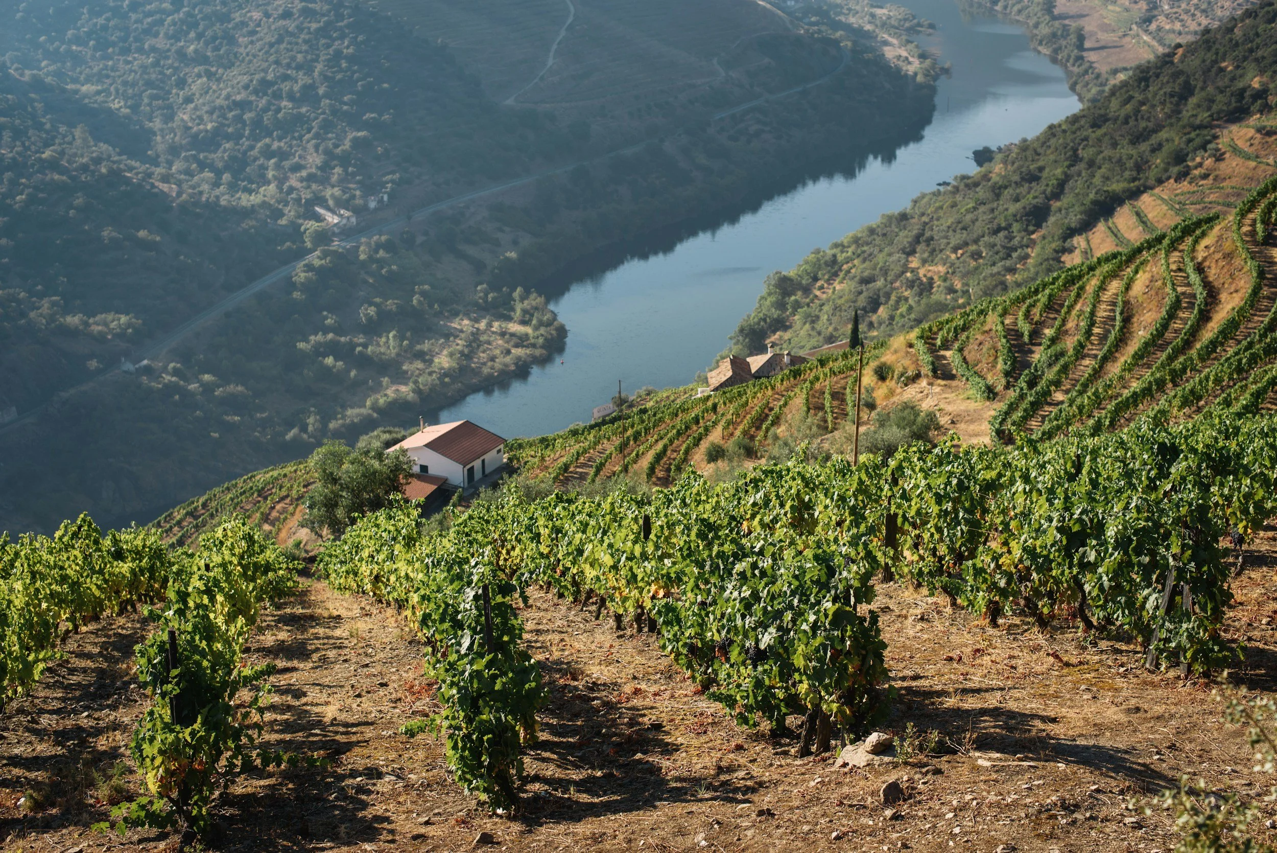
In the Douro Valley, vineyard walking feels different from places like Tuscany or Bordeaux. The land around Sabrosa is steep, and the vineyards are built in terraces that drop sharply towards the Douro River. Because of that, the walking here isn’t flat or gentle, but the views open up quickly once you start climbing.
A practical place to anchor a walk is the area around Quinta do Crasto. The estate sits high above the river, and the narrow roads that lead towards it are part of what makes walking here worthwhile. From Sabrosa, the small road that winds south towards Crasto passes through terraced vineyards and small patches of woodland. There isn’t a pavement, but traffic is light and the road is used regularly by walkers and cyclists.
If you want a marked route rather than just following the road, the PR3 – Trilho dos Miradouros do Douro is one of the most practical options in the area. The trail starts near Sabrosa and links several viewpoints above the valley, including stretches near São Cristóvão do Douro. The route mixes gravel tracks, vineyard paths, and short stretches on minor roads. It isn’t a technical hike, but the climbs are steady, and some sections are exposed with little shade, especially in the middle of the day.
There are a few things to keep in mind before you set out. There are no cafés or water points along the PR3 route, so you need to bring water with you. The nearest places for coffee or food are back in Sabrosa or down in the smaller villages closer to the river. Mobile signal can also drop in some of the valleys, so downloading a map before you start is a good idea.
Because public transport is limited here, most people reach the trailhead by car or taxi. Once you’re on the route, it’s easy to follow, and you can choose how much of it to walk. Doing part of the loop and then turning back is common, especially if you want to combine the walk with a booked visit to Quinta do Crasto later in the day. Visits to the estate need to be reserved in advance, as tastings and tours aren’t available on a drop-in basis.
This part of the Douro works best if you’re after a walk with clear views and don’t mind some uphill sections. The terrain makes the effort feel worthwhile, and you don’t need to cover long distances to get wide views over the valley.

Hiking Path PR3
Hiking Path PR3

Six Senses Douro Valley
Mosel Valley, Germany: vineyard walks near Bernkastel-Kues and the Moselsteig
Vineyard: Weingut Dr. Loosen
Hiking Path: Moselsteig Trail
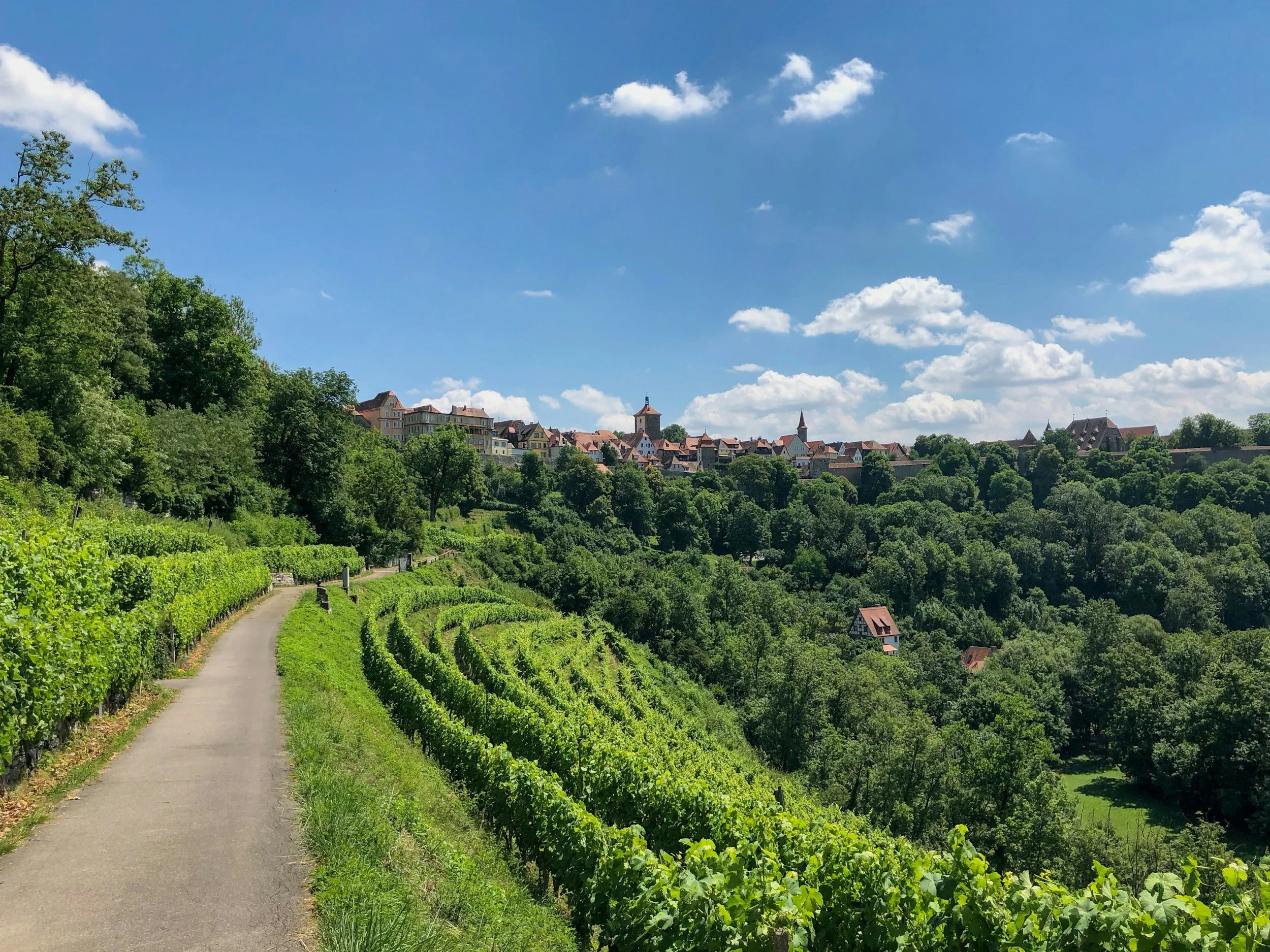
Walking in the Mosel Valley is more vertical than it looks from the river. Around Bernkastel-Kues, the vineyards climb straight up from the water, and most routes follow narrow tracks that cut across the slope rather than wide paths.
You can start directly from the old town in Bernkastel. From Marktplatz, walk down to the river and cross the bridge towards Kues, then pick up the signs for the Moselsteig near Uferallee. The path begins climbing almost immediately. The first section is a series of short switchbacks through the vines, and within 15–20 minutes you’re already above the rooftops, looking back over the river bend.
A practical route is to follow the Moselsteig towards Graach an der Mosel. This stretch keeps you on vineyard paths and small access tracks rather than forest trails, so the views stay open most of the way. You don’t need to walk all the way to Graach. Walking out for 45–60 minutes and then turning back works well, especially if you want to keep the day flexible.
Along the way, you’ll pass steep rows of vines supported by stone walls, and sections where the path narrows slightly as it cuts across the hillside. The ground is firm, but the incline is constant enough that it feels like a proper walk rather than a casual stroll. There’s very little shade on the vineyard sections, so starting earlier in the day makes a difference, especially in warmer months.
Back down in town, you can combine the walk with a visit to Weingut Dr. Loosen, located along Uferallee. It’s an easy walk from the bridge and one of the more accessible wineries in the area if you want to add a tasting. Visits are organised rather than drop-in, so it’s worth booking ahead.
Everything here is close together. You can leave Marktplatz, be on the trail within ten minutes, and back by the river not long after turning around. That’s what makes this area work so well for vineyard walking. You don’t need transport or a full-day plan to get into the landscape.
Germany is often overlooked for this kind of trip, but these boutique stays make it easier to picture where you’d actually stay between walks.
Weinhaus Halfenstube

Vineyard Weingut Dr. Loosen
Good to know before walking through vineyards in Europe
One thing that’s not always obvious before arriving is that most vineyard walks aren’t on clearly marked “hiking trails.” In places like Tuscany, Bordeaux, the Douro Valley, and the Mosel Valley, you’re usually walking on a mix of local roads, gravel tracks, and vineyard access paths. That means navigation is simple most of the time, but you won’t always see signs telling you exactly where to go. Having an offline map downloaded helps, especially in areas like the Douro where signal drops.
Access is another detail to keep in mind. You can walk through vineyard landscapes, but not all land is public. If a path runs directly through a working vineyard, it’s best to stay on the marked track or road rather than cutting across rows of vines. This is more noticeable in the Mosel and Douro, where the terrain is tighter and vineyards are actively maintained.
Timing matters more than you might expect. In the Douro Valley and parts of the Mosel Valley, the vineyard sections are exposed, with very little shade. Walking mid-afternoon in summer can feel much harder than the same route in the morning. Starting earlier or later in the day makes the walk more manageable, especially on steeper sections.
Food and water aren’t always available along the route. In areas like Gaiole in Chianti or around Sabrosa, once you leave the village, there are no cafés or shops until you return. It’s easier to bring water with you and plan your stops back in town rather than expecting to find places along the way.
In case you’re not completely set on Tuscany, places like Ascoli Piceno give you a similar feel without the same level of planning or movement between stops.
If you’re planning to visit a winery during the walk, it’s usually necessary to book ahead. Estates like Castello di Brolio, Château Pape Clément, Quinta do Crasto, and Weingut Dr. Loosen don’t typically accept walk-in tastings, especially during busier months. It’s easier to plan one stop and build your walk around it rather than relying on finding availability on the day.
Finally, distances often feel longer than they look on a map. Vineyard roads curve, climbs are gradual but constant, and in regions like the Douro and Mosel, elevation adds up quickly. A shorter walk with time to stop and take breaks usually works better than trying to cover too much ground.
How to actually make vineyard walks work in practice
The key to walking in these wine regions isn’t finding a perfect trail. It’s understanding how the landscape is stitched together once you’re there. In places like Tuscany, Bordeaux, the Douro Valley, and the Mosel Valley, the best walking usually isn’t on one famous route but on the small roads and vineyard tracks that connect villages, estates, and viewpoints.
In Gaiole in Chianti, you can step out from Via Ricasoli and follow the narrow road towards Castello di Brolio without needing to look for a trailhead. The walk starts immediately on quiet roads that climb through vines and low woodland. Around Pessac near Bordeaux, the shift happens just beyond Avenue Jean Jaurès, where the houses give way to vines and the lanes link into the paths of Les Chemins de la Vigne et du Vin. In Sabrosa, the small road towards São Cristóvão do Douro leads straight into the viewpoints on the PR3 route, and in Bernkastel-Kues, the climb begins almost as soon as you leave the bridge and reach Uferallee, where the Moselsteig signs appear.
A useful way to think about distance here is to keep it shorter than you might expect. A two-hour walk often covers enough ground to move between vineyards, reach a viewpoint, and still get back without rushing. In the Douro and Mosel especially, the slopes make even short distances feel like a proper outing, so you don’t need to commit to a long route to feel like you’ve done something worthwhile.
It also helps to anchor your day around one fixed point rather than trying to plan a full loop. That might be a booked visit at Castello di Brolio, a tasting at Weingut Dr. Loosen, or simply deciding where you’ll eat later. Once that’s set, the walking between places can stay flexible. If a lane looks quieter, take it. If a section feels too steep or exposed, turn back. The roads and paths in these regions connect in a way that lets you adjust as you go, which is often more practical than following a single trail from start to finish.
In practice, the best walks in these regions start right where you’re staying. You leave the village on foot, follow the first road that heads uphill or out into the vines, and adjust your route based on time, weather, and how far you feel like going. That approach tends to work better than trying to fit the day into a fixed route.

FAQ: vineyard walks in Tuscany, France, Portugal and Germany
Can you really walk through vineyards in Europe, or do you need to join a tour?
In many regions you can walk straight from villages into vineyards without joining a tour. In Tuscany, the roads around Gaiole in Chianti lead directly into vineyard areas. In Pessac near Bordeaux, the vineyard paths start just beyond residential streets. In the Douro Valley and the Mosel Valley, vineyard tracks and access roads are open to walkers, though some private estates require you to stay on public routes.
Where are the best vineyard walks in Tuscany?
One of the easiest areas to walk without a car is around Gaiole in Chianti. From the centre of town, you can follow local roads towards Castello di Brolio, passing vineyards and olive groves along the way. Sections of the Via Francigena also run through parts of Tuscany and connect villages on foot.
Can you walk between wineries in the Bordeaux region?
Yes, particularly around Pessac in the Graves wine region. From Pessac Centre, you can reach vineyards and walking routes such as Les Chemins de la Vigne et du Vin without needing a car. Wineries like Château Pape Clément sit close enough to town that you can combine a walk with a booked visit.
What’s the best vineyard walk in the Douro Valley?
Around Sabrosa, the PR3 – Trilho dos Miradouros do Douro connects several viewpoints above the river. The route passes through terraced vineyards and offers wide views over the valley. Sections of the walk can be done in a couple of hours, making it manageable even if you’re not planning a full-day hike.
Where can you walk through vineyards in Germany?
In the Mosel Valley, vineyard walks are easy to access from towns like Bernkastel-Kues. The Moselsteig climbs directly from the town through steep vineyards, with clear signage and open views over the Moselle River.
Do you need hiking gear for vineyard walks in these regions?
Most vineyard walks use gravel roads, paved lanes, and vineyard access tracks rather than technical trails. Comfortable walking shoes are usually enough. The main thing to consider is elevation: regions like the Douro and Mosel have steady climbs, while parts of Tuscany and Bordeaux are gentler.
Is it better to rent a car or use public transport?
It depends on the region. In Tuscany and the Douro Valley, having a car makes it easier to reach trailheads and wineries. Around Bordeaux and Bernkastel-Kues, public transport gets you close enough to walk directly into vineyard areas without needing a car.
When is the best time of year for vineyard walking?
Spring and early autumn are the most practical times. The weather is mild, the paths are usually in good condition, and wineries are open without the peak summer crowds. In hotter months, walks in the Douro and Mosel can feel more demanding due to the heat and exposed terrain.