
Castle-to-castle walks in Europe you can reach without a car
There’s a very specific kind of walk that stays with you long after the day ends. It usually starts in the middle of a small town, not at a car park. You grab a coffee, follow a narrow street out of the centre, and within minutes you’re on a path that winds through farmland or forest before climbing up toward a castle on a hill. Then, when the legs start to feel it, you drop back down into another village where you can sit down for lunch or something warm before the train home.
You can do this in places like Lewes, where the trail begins almost immediately after you leave the station. Walk up through the lanes behind the high street and you’re on the path that leads to Lewes Castle, with views across the Downs and rooftops below. Or in Dürnstein, where you leave the main street, follow a marked path past vineyard terraces, and climb up toward the ruins of Dürnstein Castle before dropping back down toward the riverfront.
What makes these walks so good is how easily they fit together. You don’t need a car, a guide, or complicated logistics. You step off a train, follow a path, reach a castle, and end up somewhere you can actually sit down for food or a drink rather than having to turn straight back. That combination of walking, local food stops, and manageable distances is what makes these routes work well for a day out without turning it into a big undertaking.

One of the macigal castles in Bavaria
Hiking the Scottish Highlands: castles, whisky and proper food stops
Pitlochry is one of the easiest places in the Highlands to base yourself if you don’t want to rent a car. The train drops you right in the centre of town, and within a couple of minutes you’re already on Atholl Road, which runs straight through the village. This is where you’ll find the essentials: a couple of bakeries, a small supermarket, outdoor shops if you forgot gloves or socks, and cafés that open early enough to grab something before a long walk.
A really good first walk is up through Black Spout Wood. You reach the entrance to the woodland path from the south side of town, near Moulin Road, and the track climbs gently through tall trees. After around twenty minutes, you reach the viewing platform overlooking the Black Spout waterfall. It’s not a huge detour, but it’s a nice way to ease into the landscape. From there, you can continue along forest tracks toward Edradour Distillery, which sits in a small glen just beyond the trees. It’s one of the smaller traditional distilleries in Scotland, and you can stop for a tasting or a short tour if you time it right. It makes a good halfway point before turning back toward town.
If you want a longer day, the route up Ben Vrackie starts just outside the village. The path is clear and steady at first, winding through forest before opening out onto heather-covered slopes. The full walk up and back takes around four to five hours at a relaxed pace. The climb is manageable for most people with reasonable fitness, but the weather can change quickly once you’re above the tree line. Even on a bright day, it’s worth packing a light waterproof and something warm.
Back in town, you don’t need to plan too hard to find somewhere to eat. Hettie’s Tearoom is a reliable stop for lunch or cake, especially after a few hours out walking. If you want something more substantial in the evening, The Old Mill Inn serves classic pub food and local beer, and it’s a comfortable place to sit down without booking far ahead.
One thing that makes this area easy to enjoy without a car is how close the walking routes are to the town itself. You don’t need a taxi to reach the start of a trail, and you don’t need to plan complex transport back. You can leave your accommodation in the morning, be on a path within minutes, and still be back in time for a late lunch or early dinner without having to think too much about logistics.
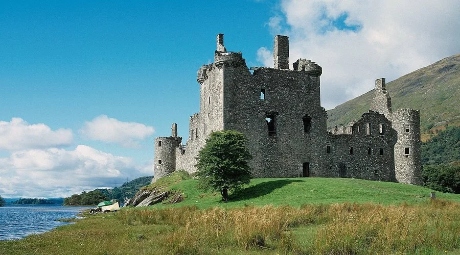
Kilchurn Castle
Exploring the Rhine Valley: castles, wine and small-town stops
The stretch of the Rhine Valley between Bingen am Rhein and Koblenz is one of the easiest parts of Germany to explore without a car, and it works especially well if you like walking, small towns, and having somewhere good to eat at the end of the day. The train line runs right along the river on both banks, stopping in almost every village, so you can get off in one town, walk a stretch of the valley, and hop back on the train later without much planning.
One of the best places to start is Bacharach. The station sits almost at the entrance to the old town, so you can step off the train and be walking through Oberstraße within a couple of minutes. The street is lined with half-timbered houses, small bakeries, and traditional wine taverns. If you walk up through the vineyards toward Stahleck Castle, the climb takes around 20–30 minutes on a clearly marked path. The route winds past stone walls and vine terraces, and there are benches along the way where you can stop and look back over the rooftops and the river. At the top, the view opens across the valley, and on clear days you can see the river curving between steep, green hills.
Further north, Sankt Goar makes another good stop. The train station sits right by the river, and the walk into town takes only a few minutes. From there, you can follow signs uphill toward Rheinfels Castle. The path climbs steadily through woodland and open sections, and it takes about 30–40 minutes to reach the castle ruins on foot. The site is large, with old tunnels, stairways, and lookout points spread across the hill. After visiting, you can head back down into town for lunch or continue along the riverside path if you want a longer walk.
If you’re interested in wine, Oberwesel is worth a stop. The town sits right on the river and still has long stretches of its medieval town walls intact, which you can walk along in parts. From the centre, small paths lead up into the vineyards behind the town. These routes are easy to follow and give you wide views over the Rhine and the surrounding hills. In the afternoon, you’ll find small wine taverns opening along the main streets, where you can sit down for a glass of local Riesling and a simple meal.
What makes this part of the Rhine Valley especially practical is how well the towns are connected. Trains run frequently between Bingen, Bacharach, Oberwesel, and Sankt Goar, so you don’t have to commit to one place for the whole day. You can walk in the morning, stop for lunch in one town, then take the train to another in the afternoon without worrying about getting back. Because the stations are close to the town centres and the walking routes, you spend your time moving rather than waiting around for transport.

Black Forest gateau

Rheinfels Castle
Trekking the Amalfi Coast: cliff paths, villages and places to stop
If you want a day on the Amalfi Coast that doesn’t involve squeezing onto buses or hiring a car, one of the most practical options is to walk the Path of the Gods. Most people start in Bomerano, a small village above the coast. The trailhead is signed from the main square near the church, and once you’re on the path, the route stays high above the sea with long views down toward the cliffs and water.
The path runs between Bomerano and Nocelle and takes around two to three hours at a steady pace. The terrain is uneven in parts, with stone steps, loose gravel, and narrow stretches cut into the hillside. You don’t need technical gear, but sturdy shoes help, especially on the rockier sections. Along the way, you pass small farms and terraced slopes where locals still grow produce, and in spring the hillsides are dotted with wildflowers. There aren’t many facilities on the trail itself, so it’s worth picking up water or snacks before you leave Bomerano.
When you reach Nocelle, you have a choice. You can walk down the long staircase that leads toward Positano, which takes around 40–50 minutes and includes several hundred steps. Or you can take the local bus down the hill if you don’t fancy the descent on tired legs. Positano itself is busy and more expensive than the villages above, but it’s an easy place to find a late lunch or a drink before heading back.
Another option is to base yourself in Amalfi and walk inland along the Valle delle Ferriere route. The path starts near the paper museum just above the town centre and follows a track up the valley. The route is shaded for long stretches, which makes it a good choice when the weather warms up. You’ll pass old stone buildings, small waterfalls, and sections where the path runs beside a stream. It’s a straightforward walk, and you can turn back whenever you want without committing to a full loop.
Food is easy to work into the day here. In Bomerano, there are small places near the main square where you can get a simple plate of pasta or a sandwich before or after the walk. In Amalfi, the area around Piazza Duomo has cafés and bakeries where you can sit down for coffee or something sweet. It’s common to see walkers stopping here before catching a bus or ferry back along the coast.
This part of the coast works well if you want to combine walking with time in the villages rather than spending the whole day on a trail. The routes are easy to follow, public transport connects the main towns, and there are enough places to stop along the way that you don’t need to plan every detail in advance.

Villa Rufolo

Wandering the Loire Valley: castles, wine and easy days on foot
If you want a few days of walking without having to rent a car, the stretch of the Loire Valley around Amboise and Blois is one of the easiest parts of France to do it. Trains run regularly along the river, so you can move between towns without worrying about buses or driving, and once you’re in each place, everything is within walking distance.
In Amboise, the train station sits just across the river. From the platform, it’s about a ten-minute walk across the bridge into the old town. You’ll cross the Loire River with the town unfolding ahead of you, and once you reach Rue Nationale, you’re already in the middle of things. This street is lined with small shops, wine bars, bakeries, and cafés, and it leads directly toward Château d'Amboise. You don’t need a map here; you’ll naturally end up at the château if you follow the flow of the street.
A short walk from the château takes you toward Clos Lucé, the former home of Leonardo da Vinci. The route runs through quiet residential streets, and the walk takes around fifteen minutes. It’s easy to do in the morning before the town gets busy. The grounds at Clos Lucé are worth taking your time with, especially the gardens behind the house where you’ll find paths winding between trees and small water features. It’s a good place to slow down for an hour before heading back into town.
If you continue west along the valley, Blois makes another practical stop. The train station sits above the town, and you can walk down toward the river and the old centre in under ten minutes. The route leads you toward Place Louis XII, where cafés and small brasseries cluster around the square. From there, it’s a short walk up to Château de Blois, which sits right in the middle of town rather than out in the countryside. That makes it easy to visit without planning transport or setting aside a full day.
Both towns also have good options for food without needing to plan far ahead. In Amboise, you’ll find small wine bars and bistros along Rue Nationale and the lanes near the river. In Blois, you’ll find cafés and casual restaurants around Place Louis XII and along the streets leading toward the river. In spring, it’s usually possible to walk in for lunch without a reservation, though dinner is better booked in advance if you have a specific place in mind.
The real advantage of this part of the Loire Valley is how simple it is to move between towns. You can spend a morning walking along the river or through the old streets of Amboise, take the train to Blois in the afternoon, and still have time to explore the château and sit down for a meal before heading back. It’s an easy way to experience the region without a car, and it works particularly well if you want a mix of walking, food, and historic places without overcomplicating the day.

Château de Chenonceau

GR3 trail
Before you plan your castle walk
One thing that really affects how these days play out is timing. In Amboise, mornings are noticeably calmer. If you walk up Rue Nationale before 10:00, you’ll pass locals picking up bread from small boulangeries before the tour groups start drifting toward Château d'Amboise. By mid-afternoon, some of the smaller cafés close between lunch and dinner, so if you finish a walk late, your options narrow until evening service starts again.
In Blois, the slope between the train station and the old town is steeper than it looks on a map. The quickest route down toward the river runs past Rue Denis Papin and the long stairway that cuts straight through the hillside. It’s an easy walk down but a noticeable climb back up if you’re catching a return train later in the day. If you’re planning to walk along the river or explore the lanes around Place Louis XII, it’s worth leaving enough energy for that uphill walk back to the station.
Train schedules matter more than people expect. The regional trains running between Amboise, Blois and other Loire Valley towns are regular during the day, but services slow down later, especially on Sundays. If you’re planning a longer walk followed by a late lunch or a glass of wine before heading back, check the return times before setting off so you don’t end up waiting on a quiet platform.
The paths themselves are straightforward, but the ground can vary. Sections through woodland or along vineyard edges get slippery after rain, and the stone steps near the châteaux can be worn smooth. Light hiking shoes make a noticeable difference, especially if you’re walking between towns rather than just around the centre.
These walks are easy to enjoy without much planning, but the small details shape the day. Starting early, knowing where the cafés actually are, and checking the return trains makes the whole experience feel smoother, especially if you’re travelling alone or want the day to stay relaxed.

FAQ about castle walks in Europe
What are the best castle-to-castle walks in Europe?
Some of the most accessible castle walks include the riverside paths and hill trails around Amboise and Blois in the Loire Valley, and the hilltop routes around Dürnstein in the Wachau Valley. These routes connect small towns, castles and viewpoints without needing a car.
Can you visit Loire Valley castles without a car?
Yes. Both Amboise and Blois have train stations within walking distance of the old town and the main châteaux. You can reach Château d'Amboise and Château de Blois on foot from the stations without taxis or transfers.
Is the Dürnstein Castle hike difficult?
The walk from Dürnstein up to Dürnstein Castle is short but steep in places. It usually takes around 20–30 minutes uphill on a rocky path with some uneven steps. Good shoes help, especially if the ground is damp.
How long are these castle walks?
Most of these routes are manageable as half-day walks. Expect between one and three hours of walking depending on the route and how long you spend at viewpoints or in the towns.
Do you need hiking gear for these walks?
You don’t need technical equipment, but proper walking shoes are recommended. Paths around vineyards and castle ruins can be uneven, and stone steps near the castles can be slippery after rain.
Are these castle walks suitable for solo travellers?
Yes. The paths are well used, and the routes start and end in small towns where you’ll find cafés, restaurants and regular train connections. That makes them practical if you’re travelling alone.
What’s the best time of year to walk these routes?
Late spring through early autumn is ideal. Paths are drier, and cafés and wine bars in places like Amboise, Blois and Dürnstein keep longer opening hours during these months.
Can you reach these walks by train?
Yes. Amboise and Blois are served by regular regional trains along the Loire Valley line. Dürnstein can be reached by train to Krems an der Donau followed by a short bus ride or cycle along the river.