
Castle walks in Europe for summer (routes between historic towns)
You get off the train in St. Goarshausen, walk past the station onto Heerstraße, and within a couple of minutes you’re already heading uphill without checking a map. The path pulls you out of the town quickly. After about twenty minutes, you stop, turn around, and realise you can see Burg Katz just above where you started and Burg Rheinfels directly across the river in St. Goar.
You haven’t planned a route. But it’s obvious you can keep going and end up somewhere else.
That’s the difference this post is built around.
Most castle trips don’t connect… You drive to Château de Chenonceau, park, walk through it, leave, then do the same somewhere else. Or you stop at Urquhart Castle on the road along Loch Ness, take a look, then get back in the car. It works, but it doesn’t build into anything.
There are a few places where it does.
Along the Rhine, towns like St. Goarshausen, Kaub and Bacharach sit close enough that you can walk between them on the Rheinsteig and still catch a train at the end. In the Loire Valley, it’s shorter connections. You move between Amboise and Chenonceaux, walk sections along the river or through vineyards, then continue later in the day.
In the Scottish Highlands, it shifts again. You follow the A82 past Loch Ness, stop at Urquhart Castle, then continue into Glen Coe, where the walking isn’t about reaching a specific place but stepping out from the road for 20–30 minutes at a time. It’s less structured, but the movement still builds through the day.
And in the Czech Republic, between Český Krumlov, Rožmberk and Šumava, the distances are short enough that you can link them without it turning into a long drive, but each place works differently once you arrive.
That’s usually where things fall apart when you try to plan it. On a map, it looks easy to connect everything. In reality, some sections work on foot, some don’t, and some are better kept short.
This guide is built around that.
Where you can actually walk between castles without doubling back. Where it’s easier to stop and continue later. And how to move between these places in a way that doesn’t turn into constant driving or trying to fit too much into one day.
The Rhine Valley, Germany
You arrive in St. Goarshausen, step out of the station, and the river is right there. Across the water sits St. Goar, with Burg Rheinfels spread across the hillside above it. It’s one of the largest castle ruins on the Rhine, and you can see how far it stretches even from here. Closer to where you’re standing, just above the rooftops of St. Goarshausen, is Burg Katz. It’s more compact, built higher and tighter, and easier to spot once you start climbing.
Walk along Heerstraße for a couple of minutes, then follow the signs uphill toward the Rheinsteig. You turn, and the climb starts immediately. As you gain height, the distance between the castles becomes clearer. Burg Rheinfels isn’t just one structure, it’s a series of walls and terraces that used to control this part of the river. Burg Katz, on the other hand, was built later, more as a defensive point facing the opposite bank.
Once you’re above the town, you start to see why so many castles sit along this section of the Rhine. The river narrows here, and historically this was one of the main trade routes through the region. Castles weren’t built for decoration. They controlled movement along the river, collected tolls, and watched what passed through.
As you continue along the ridge, you won’t visit most of the castles directly, but you keep seeing them from different angles. Further south, near Kaub, the setting changes slightly. Instead of a castle on a hill, you get Burg Pfalzgrafenstein, which sits directly in the river on a small island. It was used as a toll station, which makes more sense when you see its position. Nothing could pass without going around it.
Above Kaub, you’ll also notice Burg Gutenfels, set back on the hillside. It’s less obvious at first, but once you’ve come down into the town and look back up, you see how it overlooks the same stretch of river from a higher point.
Around Loreley, the landscape itself becomes part of the story. The river bends tightly around a steep rock face, and this is where the well-known legend comes from. It’s also why castles were placed carefully along this section. Visibility mattered, and the bend in the river created a natural point of control.
What makes this route different is that you’re not moving from one castle to the next in a structured way. You’re walking above them, seeing how they relate to each other and to the river. Some sit directly above towns, others are set further back, and one sits in the water itself. By the time you reach Kaub, you’ve seen several without needing to stop at each one.
If you’re planning to base yourself somewhere comfortable between walking days, boutique stays makes it easier to choose places that actually feel worth returning to in the evening.
Some of the most satisfying castle walks in Germany sit right on the edge of forested spa towns, which is why Black Forest tends to come up once you start mapping routes properly.
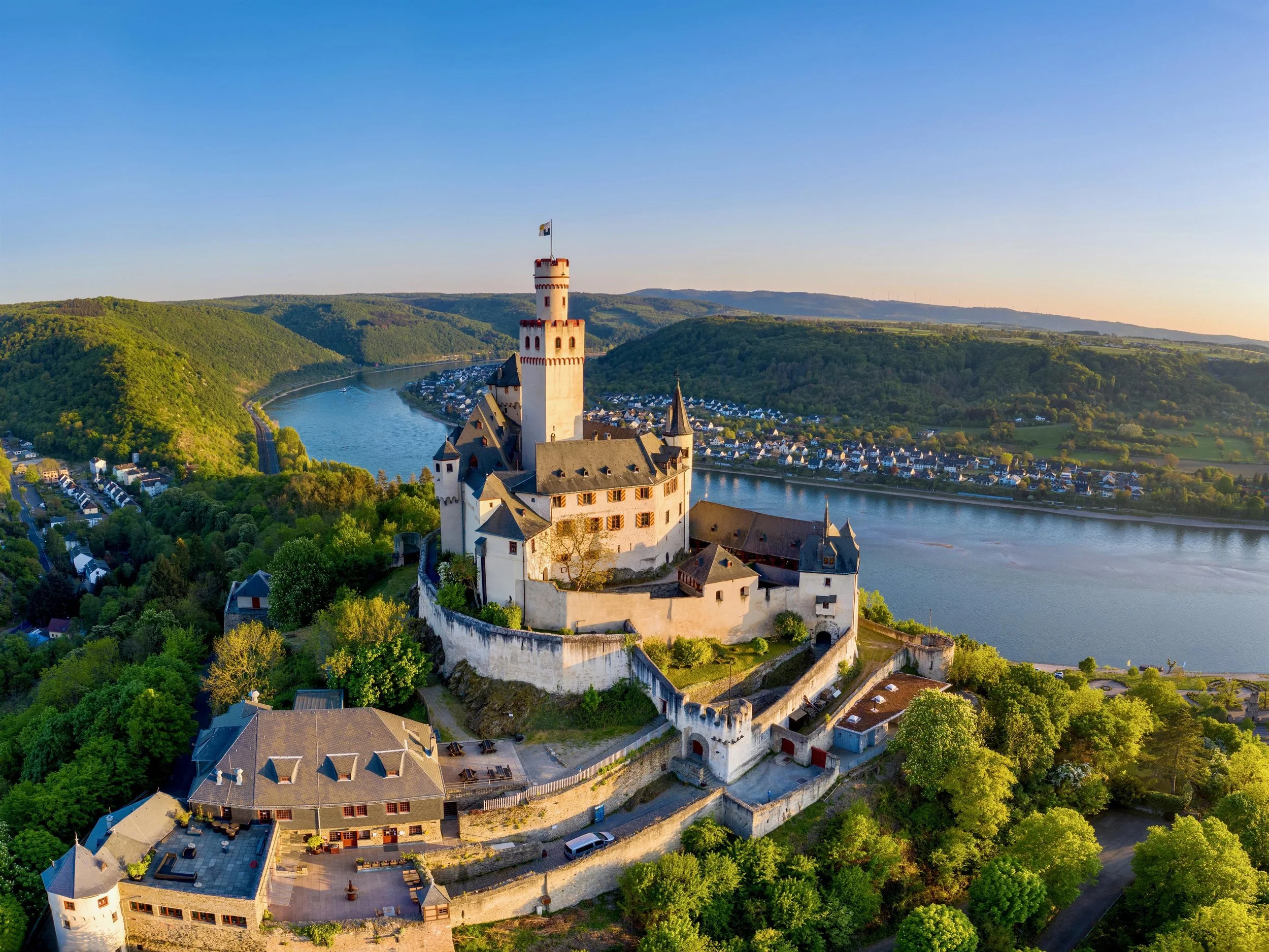
Marksburg castle

Rhine valley view
The Loire Valley, France
You don’t arrive into “the Loire Valley” in one moment. You come into it gradually, usually by train or car from Tours, then realise the castles aren’t grouped together the way you might expect. They sit between towns, along smaller roads, and you move through them one at a time rather than ticking them off in one place.
A good stretch to focus on is Amboise → Chenonceaux → Tours, all within about 30–40 minutes of each other. That distance matters because it means you can shift between places without needing to plan full days around transport.
Start in Amboise, where everything is easy to read straight away. The town sits along the Loire, with Quai du Général de Gaulle running parallel to the river. You walk along it, pass a few cafés, then look up and see Château Royal d’Amboise rising directly above the town. It’s not set back or hidden. It dominates the skyline in a way that feels immediate.
If you cross the bridge toward Île d’Or, you get the clearest view back toward the château. This is where people usually stop, not because it’s marked as a viewpoint, but because it naturally opens up. From here, you can also see how close everything is. The town, the river, and the château all sit within a few minutes of each other.
A short walk from the centre, along Rue Victor Hugo, is Clos Lucé, where Leonardo da Vinci spent his final years. It’s about 10 minutes on foot from the château, and the route takes you through a residential part of town rather than something built for visitors. It’s one of the few places where the history connects directly to a specific building rather than just the setting.
From Amboise, heading toward Chenonceaux changes the structure completely. You can drive in about 20 minutes or take the train to Chenonceaux station, which is a few minutes’ walk from the entrance. The approach matters here. You don’t see the château from the road. You walk through a long, straight avenue of trees, and only at the end does Château de Chenonceau appear.
It sits directly over the River Cher, not beside it. The arches run underneath, and you can walk through rooms that span the water itself. Around it, the grounds are laid out in a more formal way, with Catherine de’ Medici’s garden and Diane de Poitiers’ garden on either side. If you walk beyond the main areas, paths lead out along the riverbanks where it becomes quieter again.
The walking here isn’t one continuous route. It’s smaller connections. You move from the château grounds to the river, then back toward the village, then on again. The terrain is flat, so distance is what shapes the day rather than elevation.
Continuing toward Tours, the landscape opens out more. Around Montlouis-sur-Loire and Vouvray, vineyards start appearing directly along the roadside and footpaths. You’ll see small signs for local producers rather than large estates. Some are set into the hillside, with entrances leading into troglodyte cellars carved into the rock. It’s not something you need to book in advance to notice. You pass them as you move between places.
In Tours, everything tightens again. The centre around Place Plumereau is more compact, with older buildings, cafés, and a different pace compared to the smaller towns. It’s a place you end up after moving through the valley rather than somewhere you start.
What makes this part of the Loire work is how spread out it is. You’re not moving between castles that all look the same or sit in the same position. Amboise rises above the town, Chenonceau sits across the water, and others are set back among vineyards or woodland.

Château de Chaumont-sur-Loire
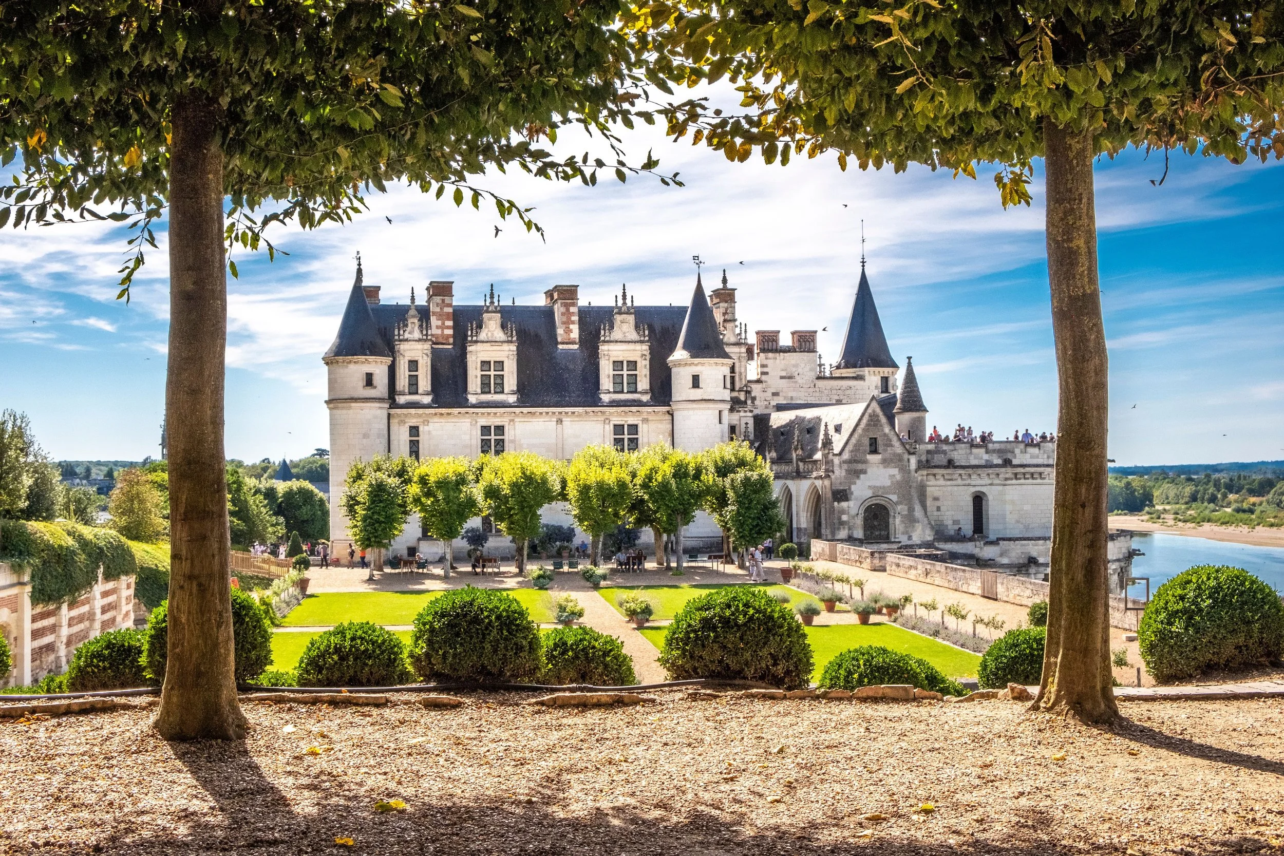
Loire valley
The Carpathian Mountains, Romania
You usually arrive into this part of Romania through Brașov, and that’s where it helps to understand what’s actually where before heading out. The mountains sit just outside the city, and the castles people associate with “Dracula” aren’t in one place. The most visited one, Bran Castle, is about 30 minutes from Brașov, in the village of Bran, right along the road toward Moieciu.
If you drive or take the bus from Brașov, you come in along DN73, pass small roadside stalls selling local cheese and honey, then see the castle before you reach the centre. It sits above the road on a rocky hill, not far from the main junction, which is why it feels more immediate than expected when you first see it.
Walking up to Bran Castle is short but direct. You pass through a small market area at the base, then follow a stone path and steps up toward the entrance. Once you’re inside, the layout is tighter than people expect. Narrow staircases, small rooms, and inner courtyards rather than large open halls. It doesn’t take long to walk through, but it’s more about how the spaces connect than how much there is to see in each room.
The connection to Dracula is more indirect than most people think. The character comes from Bram Stoker’s novel, but Vlad Țepeș, the historical figure often linked to Dracula, didn’t actually live here in a clear, documented way. The castle fits the image, though, which is why it’s become associated with the story.
If you want to turn this into a walking route rather than just a visit, it’s better to move beyond the castle itself. From Bran, you can head toward Moieciu de Sus, where the road narrows and opens into the foothills of the Carpathians. From there, smaller paths lead into the surrounding hills, often starting right from the village roads without needing marked trailheads.
Another option is to base yourself closer to Zărnești, on the edge of Piatra Craiului National Park, about 40 minutes from Bran. This area feels more like a starting point for walking rather than sightseeing. Trails begin near the town and lead into the mountains, with routes ranging from short valley walks to longer climbs.
What makes this area different from the Rhine or the Loire is that the castle is only one part of it. Bran Castle is easy to reach and quick to visit, but the surrounding landscape is what gives it context. You move from a very defined place into something much more open within a short distance.
A lot of these routes naturally pass through wine regions without making a big deal of it, so wine regions is worth checking before you decide where to stop overnight.
If you want something that feels a bit more layered historically, with longer distances between towns, Transylvania is often where people start looking next.


The Scottish Highlands, Scotland
You usually leave Inverness thinking you’ll follow the A82 along Loch Ness, stop at a couple of places, then continue on. It looks simple. One road, a few stops, everything in a line.
It doesn’t stay that straightforward once you’re driving it.
You cross the river in Inverness, pass the last stretch of houses, and within ten minutes the road is already tight against the edge of Loch Ness. There aren’t many places to stop at first, so you keep going, watching the water appear and disappear between trees. Then a lay-by opens up, a few cars already there, and you pull in without planning to. You get out, stand there for a minute, then move on again.

Eilean Donan Castle
The first place where you properly stop is usually Urquhart Castle, just outside Drumnadrochit. You’ll see the signs early, turn off, park, and walk down the path toward the ruins. It’s worth pausing before going inside. From the viewpoint above, you can see how the castle sits directly on the loch, with the water stretching out behind it and hills rising on the opposite side. It’s one of the few places where everything is laid out clearly in front of you.
Back on the A82, the drive continues in that same rhythm. You follow the loch for a while, then the road pulls away from it, then comes back again. Small lay-bys appear without warning. Some are just wide enough for two or three cars. Others open slightly more. You start to recognise the pattern. Cars already there usually mean something is worth stopping for, even if it’s not marked.
By the time you reach Fort William, you’ve already stopped more than you expected. The town itself feels practical. You park near the centre, walk a short stretch along the high street, maybe stop somewhere like The Grog & Gruel or one of the cafés nearby, then get back on the road. It’s not where most people stay long, but it breaks the drive before the next section.
From Fort William, heading into Glen Coe, the change is immediate. The road narrows slightly, but the space around you opens up. You pass through a wide valley with steep sides, and the scale becomes the focus rather than any single stop. Cars pull into places like the Three Sisters viewpoint or along smaller roadside spots where there’s just enough room to stop.
You don’t follow a set walking route here. You park, step out, walk 10–20 minutes into the landscape, then come back. Maybe you follow a faint path, maybe you don’t. The ground is uneven, sometimes wet, and you adjust as you go rather than committing to a full hike.
If you continue further west or plan a separate day, Eilean Donan Castle near Dornie is one of the few places that feels more defined again. You approach it along the A87, come around a bend, and it’s directly in front of you, sitting on a small island where three lochs meet. There’s a small car park just before the bridge. You walk across, but even from the roadside you already understand the setting.
Another option slightly closer to Inverness is Castle Stalker, near Appin, which sits on a tidal islet. You don’t walk to it in the same way. You stop along the roadside viewpoint, look out, and that’s enough.
If you’re comparing this kind of trip with something more coastal and open, Ayr guide gives a very different version of what a slower route can look like.
Want to combine the Highlands with a city weekend? For a route that mixes castles with bookshops, old streets, and somewhere to stop without rushing, Edinburgh spring is one of those combinations that works surprisingly well.

Urquhart Castle

The Czech Republic: castles and Bohemian forests
You usually come into this part of the Czech Republic from Prague, and the shift happens faster than expected. Once you’re past Benešov and heading south, the roads narrow, the traffic drops, and towns start feeling more like places people actually live in rather than somewhere you’re meant to pass through quickly.
A practical stretch to focus on is Český Krumlov → Rožmberk nad Vltavou → Šumava National Park. It looks like a short route on a map, but each stop works differently once you’re there, which is why it doesn’t feel repetitive.
In Český Krumlov, you don’t drive into the centre. You leave the car outside, usually at P1 (Jelenka) just above the old town or P3 on the opposite side, then walk in. The first few minutes don’t feel like much. You’re passing outer walls and quieter streets, then the ground drops slightly and the town closes in around you.

Once you reach the river, the layout starts to shift. The Vltava loops tightly around the centre, and the streets follow it in narrow curves. You walk along Latrán, pass under the castle complex, and move through a sequence of archways and courtyards without really deciding where to go. One turn leads into another, then you come out somewhere higher up than before.
Instead of heading straight into the castle interiors, walk out toward the Cloak Bridge (Plášťový most). It connects parts of the castle complex and sits high above the town. From there, you can see how the rooftops, the river, and the castle all sit on top of each other rather than being separate points. If you continue a bit further, the castle gardens open up behind, and it becomes quieter quite quickly compared to the centre.
When you leave Krumlov, the road toward Rožmberk nad Vltavou follows the river closely. It bends constantly, passes through small villages, and you’ll notice fewer cars the further you go. When you arrive, you don’t need to search for the castle. It’s already visible above the town as you cross the bridge.
Parking is simple near the centre. From there, you walk across the small bridge over the Vltava, pass a few houses, and follow the road uphill. The path to Rožmberk Castle is direct and takes about 10 minutes. Once you’re at the top, the view is narrower than in Krumlov, with the river cutting through a tighter valley and forest covering most of the surrounding hills.
If you continue further, the shift into Šumava National Park happens gradually, then all at once. Villages like Horní Planá still feel connected to the river, but by the time you reach Kvilda or Modrava, you’re fully in forested terrain. Houses are spaced out, roads are quieter, and there’s less sense of a central place to arrive into.
Walking here doesn’t start from a defined “main” point. Around Kvilda, you’ll see small parking areas near the road with trail signs rather than visitor centres. One of the easier routes is toward Jezerní slať, where a wooden boardwalk takes you out over open peat bog. It’s flat, slightly elevated, and you stay above the ground rather than walking through it.
From there, you can continue along forest tracks that run for long stretches without major changes in direction. Paths are marked, but you’re not following a loop in the same way as other regions. You walk out, turn when you feel like it, and come back the same way.
Around Modrava, the setting shifts again. Several rivers meet here, and you’ll see wider gravel paths following the water rather than cutting through the forest. It’s easier walking, but more exposed, and you’ll pass a few cyclists as well as walkers.
What makes this area work is how each place resets the pace. Český Krumlov is compact and layered, with streets that turn quickly and keep you moving. Rožmberk is quieter and more direct, where you go up to the castle and back down without much in between. Šumava removes most of that structure, leaving you with longer stretches of forest where you decide how far to go once you’ve already started.
Some routes in this part of Europe work just as well outside summer, especially if you’re thinking about quieter trails, and Bavarian Forest shows how that shift actually changes the experience.
If you’re building this as part of a longer Central Europe trip, Brno guide fits in more naturally than most people expect.

Castle Trosky
A few things that actually help once you’re there
You’ll notice most of this on the first day, but it’s easier if you already know it.
In Český Krumlov, don’t try to “time it perfectly,” just change how you use it. Walk the centre early, before 9:30, when Latrán and the small bridges over the Vltava are still quiet. Then leave. Come back later in the day instead of staying through the middle when everything compresses around the same few streets.
Parking is simple if you don’t overthink it. Use P1 (Jelenka) if you’re coming from the north, or P3 if you’re approaching from the other side, then leave the car there. Moving it between short stops doesn’t save time, it just slows you down.

When you drive to Rožmberk nad Vltavou, it’s a different rhythm. You arrive, park near the bridge, walk up to the castle, then come straight back down. That’s it. If you try to stretch it into something longer, it doesn’t really add anything. It works because it’s short and direct.
Between Krumlov and Rožmberk, the road along the river looks quick on a map, but it isn’t. It bends constantly, and you’ll slow down more than expected. Leave a bit of space between stops instead of trying to stack them.
In Šumava, the one thing that catches people off guard is how early the day ends. In places like Kvilda and Modrava, kitchens often close earlier than you think. If you finish a walk at 16:30–17:00, you’re already close to the edge of what’s open. It’s easier to eat first, then walk, or at least know where you’re heading back to.
Signal drops as well. Around Jezerní slať or the forest tracks outside Modrava, it’s patchy. Check your route before you leave the car rather than trying to adjust halfway through.
And in the forest, distances feel different. Paths are long, straight, and look the same for a while, so it’s easy to keep going without realising how far you’ve walked. It’s not difficult terrain, but it’s worth deciding roughly how long you want to be out before you start.
FAQ: walking between castles in Europe
What are the best places in Europe to walk between castles?
The most practical regions are the Rhine Valley (Germany), Loire Valley (France), Scottish Highlands, and southern Czech Republic (Český Krumlov to Šumava). These areas have castles spaced close enough to connect on foot, with towns in between.
Can you actually walk between castles in Europe or is it mostly driving?
In some regions, you can walk full sections. The Rhine Valley is the easiest, with marked trails like the Rheinsteig between towns. In the Loire Valley and Czech Republic, it’s more about combining shorter walks with short drives or trains.
Which European castle route is best without a car?
The Rhine Valley in Germany is the most practical without a car. Trains run along both sides of the river, so you can walk between towns like St. Goarshausen and Kaub, then continue by train.
How many days do you need for a castle walking trip in Europe?
3–5 days works best for one region. Trying to combine multiple countries in one trip makes the routes feel rushed. Each area is better treated as its own short itinerary.
What is the easiest castle walk in Europe for beginners?
The Rhine Valley is the easiest starting point. Paths are well marked, distances between towns are manageable, and you can leave the route at multiple points using the train.
Are castle walks in Europe well signposted?
It depends on the region. Germany (Rhine Valley) and parts of France are well marked. In the Scottish Highlands and Šumava, routes are clearer on the ground but less structured, so you follow paths rather than fixed loops.
What is the best time of year to walk between castles in Europe?
Late spring to early autumn works best. Spring is quieter and easier to move through without crowds, while summer has longer daylight but busier towns.
Do you need to book accommodation in advance for these routes?
In popular areas like the Loire Valley or Scottish Highlands, it’s better to book ahead in summer. In quieter regions like Šumava or smaller Rhine towns, you’ll have more flexibility, especially midweek.
What should you expect from castle visits on these routes?
Not all castles are meant to be visited inside. Along the Rhine, many are seen from the path rather than entered. In the Loire Valley, castles like Chenonceau are designed for full visits, while others are best viewed from outside.
Which castle route in Europe has the best scenery?
The Scottish Highlands offer the most dramatic landscape, especially around Glen Coe. The Rhine Valley combines scenery with density of castles, while the Loire Valley is more open, with vineyards and riverside paths.
Is the Loire Valley or Rhine Valley better for castle walking?
The Rhine Valley is better for continuous walking routes. The Loire Valley works better as shorter walks between château visits, often combined with cycling or driving.
What makes castle routes in the Czech Republic different?
Around Český Krumlov and Šumava, the castles are part of a wider landscape that includes forests and small towns. The walking is less structured, and routes are more flexible compared to the Rhine.